Myriad Uranium: Ground Geophysics Completed at Red Basin; 100% Ownership Now Secured
- HoldCo Markets

- Nov 27, 2025
- 4 min read
DISCLAIMER: Any written content contained herein should be viewed strictly as analysis & opinion and not in any way as investment advice. Visitors to this site are encouraged to conduct their own due diligence. As a Research Spotlight product, HoldCo Markets has received financial compensation for the written content and analysis below. Please read the full disclaimer here: holdcomarkets.com/disclaimer
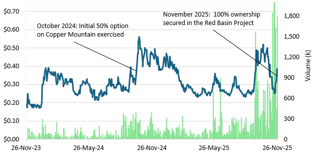
On November 26 Myriad Uranium (M) announced that a high resolution ground geophysics program was completed at the Red Basin project, located in New Mexico. Given the completion of the program, Myriad has successfully fulfilled the final requirement to earn a 100% interest in the project.
Following the cash and share payments aggregating C$525,000 (made at time of option announcement on January 30, 2025), all that was needed for full option exercise was the commencement of a geophysical program survey within 12 months of option announcement. Now that Myriad has fully earned 100% of the project, a second highly prospective asset has been added to the company’s portfolio. The Red Basin project shares many similar characteristics to Myriad’s flagship Copper Mountain project, namely the fact that both projects have benefitted from an extensive historic drilling campaign. Similarly to how Myriad is currently re-analyzing historic data and re-testing historic drill holes at Copper Mountain (Wyoming), we would expect the same methodology to unlock value at the Red Basin project as well. That said, we maintain our C$0.62 per share price objective which equates to upside of +61% from the most recent close.
EXTENSIVE HISTORIC DRILLING AT RED BASIN
Located in the Red Basin area of the Datil Mountains in Catron County, New Mexico, the general area has been estimated to contain a rich endowment of both uranium and vanadium mineralisation. Specifically, a 1981 file report produced by the New Mexico Bureau of Mines and Minerals estimated that the Red Basin area may contain as much as 30M-45M lbs U3O8, along with a significant vanadium resource. Exploration and minor production in the Red Basin district dates back to the 1950s with approximately 1,194 lbs of U3O8 produced from ore with an average grade of 0.17% U3O8. Gulf Oil and Occidental Petroleum drilled more than 1,050 holes in the Red Basin project area in the late 1960s through the early 1980s, most of which are located within Myriad’s current claim areas. That said, the project itself covers approximately 1,776 acres (or approximately 719 hectares), located in the Pietown Uranium District.
Mineralisation is hosted in channelised roll-front deposits within permeable sandstones of the Crevasse Canyon Formation and pre-Baca Formation paleosols. Historical drilling on the Project has delineated a thick section of roll-front type uranium-vanadium mineralisation cropping out on the surface to approximately 450ft down dip. A 1980 assessment of uranium resources in the Colorado Plateau physiographic province (conducted by the U.S. Department of Energy) estimated that Myriad’s Red Basin project contains approximately 1.6M lbs U3O8 at an average grade of 0.31% U3O8. More recently, in 2012 Rio Grande Resources Corporation estimated an Inferred resource between 1.5M-6.5M lbs U3O8 (when using a grade times thickness (GT) cutoff of 0.25 and grade cutoff of 0.02%). This estimate was not NI43-101 compliant.
GROUND GEOPHYSICAL SURVEY
Myriad’s recently completed magnetic and radiometric surveys were conducted at 50m line spacing along a north-south orientation. The magnetic survey was completed with 160 line-km of total data collected while gamma mapping covered 142 line-km over the same grid area. The magnetic image shows channel-like features that appear to correlate with existing drainage patterns for the most part but may also give indication of sub-surface channels. Final data and outputs are expected in the coming weeks.

The magnetic image shows channel-like features that appear to correlate with existing drainage patterns for the most part but may also give indication of sub-surface channels. Further interpretation and ground-truthing of the data and its determination of its utility for exploration targeting is still planned.

VALUATION
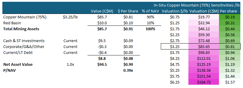
Using the historic Copper Mountain resource as a weighted benchmark, we continue to apply our $3.25 per lb in-situ valuation along with a target NAV multiple of 0.60x. Factoring in the other assets along with corporate adjustments (a recent C$8.6M financing), we maintain our in-situ based price objective (12 months) of C$0.62 per share. This equates to potential upside of +61% from the most recent close (November 26). Shares of the company currently trade at a 0.39x NAV multiple.

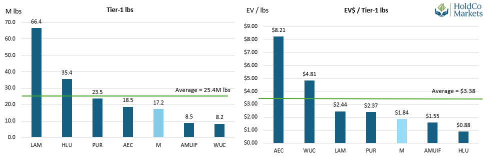
PEER VALUATION

CONCLUSION
Following the cash and share payments aggregating C$525,000 (made at time of option announcement on January 30, 2025), all that was needed for full option exercise was the commencement of a geophysical program survey within 12 months of option announcement. Now that Myriad has fully earned 100% of the project, a second highly prospective asset has been added to the company’s portfolio. The Red Basin project shares many similar characteristics to Myriad’s flagship Copper Mountain project, namely the fact that both projects have benefitted from an extensive historic drilling campaign. Similarly to how Myriad is currently re-analyzing historic data and re-testing historic drill holes at Copper Mountain, we would expect the same methodology to unlock value at the Red Basin project as well. That said, we maintain our C$0.62 per share price objective which equates to upside of +61% from the most recent close. Refer to our August 8, 2025 initiation of coverage report for added details and analysis.
NEAR-TERM TIMELINE & POTENTIAL CATALYSTS
Geophysical surveys for Copper Mountain.
Consolidation of the Copper Mountain project. Negotiations on-going with Rush Rare Metals.
Details for any upcoming drilling campaign.
An eventual NI43-101 resource estimate for Copper Basin.
An eventual TSXV listing and/or a US listing.


